River transport, general characteristics
Water (river) transport is transport that carries passengers and cargo by ships along waterways of both natural origin (rivers, lakes) and artificial ones (reservoirs, canals). Its main advantage is its low cost, thanks to which it occupies an important place in the country's federal transport system, despite seasonality and low speed.
Advantages and disadvantages
Russian river transport plays important role in inter-district and intra-district transportation of our country. Its advantages lie in the routes of natural origin, the construction of which requires fewer costs than the construction of railways and highways. The cost of freight transport by waterway is lower than by rail. And labor productivity is 35 percent higher.
However, river transportation has a number of disadvantages - it is seasonal, low speed movement, limited use, which is determined by the configuration of the water network. In addition, the major arteries of our country flow from north to south, and from south to north, and the main cargo flows have a latitudinal direction.
Main highways
Thanks to the construction of cascades of waterworks, the Volga and Kama rivers turned into deep-water highways. The inter-basin connections Moscow-Volzhskoe and Volzhskoe today constitute a Unified deep-water system, the total length of which is 6.3 thousand kilometers. With the steady growth of inland water transport in the eastern part of Russia, the leading position is still held by the Volga-Kama basin. Its rivers account for more than fifty percent of the transport of passengers and goods. The main place in this basin was occupied by river transport of construction materials (60 percent). Their transportation is carried out in both directions, it is predominantly intra-district in nature.
What is transported along Russian waterways?
River transport on these arteries mainly delivers timber, both on ships and the old-fashioned way, on rafts, by rafting. Siberian timber is transported from the Kama to the Volga, and timber from the Vologda and Arkhangelsk regions, Karelia for the North Caucasus and Volga regions is transported along the Volga-Baltic route. Moscow river transport is involved in the transportation of timber along the canal of the same name to the Moscow region and Moscow. Kuznetsk coal is transported into the basin through the ports of the Volga and Kama, and then it is transported along waterways to power plants. In addition, the delivery of salt occupies a prominent place - from the Baskunchany salt mine up the Volga to the ports of the Volga region, the Urals, the Center, to North-Western enterprises and for export. In addition, agricultural products from Volgograd and Astrakhan regions, fish from the Caspian Sea, as well as chemical products from the Volga region and the Urals. Petroleum products and oil, grain cargoes are transported in both directions.

Main directions
River transport in Russia is especially developed in the Volga-Kama basins, because the Kama with its tributaries - the Vyatka and the Belaya - is important in connecting the Urals with the North-West, the Center, and the Volga region. Mainly grain, timber, oil, chemical cargo, and construction mineral materials are transported down the Kama. In the opposite direction, coal, cement, and timber are transported. In the upper reaches of the Kama, freight traffic is significantly less. In addition, the Volga-Don Canal contributed to an increase in the transportation of bulk cargo along the Volga. Thanks to it, grain, coal, melons, industrial products and other cargo are transported along the Volga from the regions adjacent to the Don. In the opposite direction - cement, ore, timber, chemical products. All this is transported by river transport. Samara, like other cities in the Middle Volga region, is the main consumer of these goods. A major role in the development of transportation is played by water transport connections of this basin with the North-Western region, as well as with foreign countries of the Baltic Sea through the Volga-Baltic route. Apatite concentrate, ore, building materials, and timber are transported through it to the south, and chemical cargo, grain, coal and petroleum products to the north.
Passenger Transportation
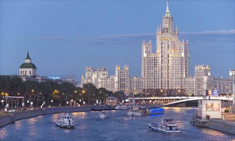
The main passenger flows were also concentrated in the Volga-Kama basin. Any river station will offer citizens a variety of local, transit, intracity and suburban destinations. Passenger ships are quite widely used in organizing tourism or recreation. The longest transit lines are from Moscow to Astrakhan, Perm, Rostov and Ufa. The largest river station is located in the capital of Russia. In the Volga-Vyatka basin the largest river ports are Nizhny Novgorod, Volgograd, Moscow, Perm, Astrakhan, Kazan, Yaroslavl.

North-west direction
Since ancient times, rivers have served as the central transport communications of the Northwestern and Northern economic regions. In its European part, the main waterways for the transportation of goods are the Northern Dvina with its tributaries Sukhona and Vychegda, Pechora, Mezen, and in the North-West - the Svir, Neva and the White Sea-Baltic Canal. The northern waterways carry a powerful flow of mineral construction and petroleum materials, timber, as well as grain and coal. The main ports are Naryan-Mar, Pechora, Mezen, Arkhangelsk, Kotlas.
The North-Western basin ensures the delivery of timber and apatite concentrate from the Kola Peninsula to the south from Karelia. In the opposite direction - industrial goods, grain, salt and petroleum products. Volkhov, Petrozavodsk and St. Petersburg serve as transshipment points for various goods. From here, permanent passenger lines are organized to Moscow and the Verkhnevolzhsky region. Local routes are also well developed here, this has become especially noticeable with the increase in the number of high-speed ships.
East direction
In eastern Russia, the Ob-Irtysh basin of Western Siberia occupies the first place in terms of transportation. River transport here contributed to the development of gas and oil resources, as well as forests. From the main transport transshipment hubs (Tobolsk, along the Irtysh and Ob, coal, drilling equipment and pipes, building materials, food and industrial goods are supplied to the oil and gas fields of the Tyumen region. Delivery of goods to the inland areas of the mainland is carried out along the Northern Sea Route with subsequent transshipment at the mouths of the Taz, Pura and Ob rivers, most of the shipments are timber, which arrives in rafts at the river port of Asino. It is then transported by ship to Novosibirsk, Omsk, and Tomsk. More than a quarter of the deliveries along the Irtysh and Ob rivers are construction materials. which come from the southern regions to the north, to the areas of the oil and gas industry. In addition, river transport is of great importance in the transportation of grain cargo, salt, coal and petroleum products.
On the Ob, along with the ancient ports of Barnaul and Novosibirsk, an important role is played by the ports that arose in connection with the creation of industrial centers - Surgut, Ob, Labytnangi, Salekhard.
Yenisei and Angara
River transport of the Yenisei connects the southern part of Eastern Siberia with the Arctic regions. Here, timber transportation reaches two-thirds of the total freight turnover of the Yenisei. In addition, grain, oil products, coal and mineral building materials are transported along the river. The Upper Yenisei, from Minusinsk to Krasnoyarsk, is characterized by a predominance of downstream cargo flow, with grain occupying the main place in it.
The mouth of the Angara: the bulk of the timber comes from here and divides the flow of goods on the Yenisei. The main part goes up, and from the mouth to Dikson - down the river. In addition to timber, transportation of construction mineral materials and coal plays a significant role. The main ports are Krasnoyarsk, Yeniseisk, Dudinka, Igarka, and on the Angara - Makaryevo, Bratsk, Irkutsk, Ust-Ilimsk.

Lena and Cupid
On the Lena, shipping starts from the port of Osetrovo and extends to the river delta. Here, in addition to domestic goods, cargo is delivered that comes from the railway - from Tiksi Bay and Osetrovo. Two-thirds of the traffic is coal and building materials, the rest is timber and oil. Most of them go from top to bottom. Cargo operations are carried out in the ports of Kirensk, Osetrovo, Yakutsk, Vitim.
In the Far East, the Amur and its tributaries Bureya and Zeya are of great transport importance. The main cargoes are grain, salt, metal, coal, timber, oil and fish. Large ports are Komsomolsk-on-Amur, Blagoveshchensk, Khabarovsk. In these areas, due to the insufficiently developed infrastructure of land communications, river transport is also important in the transportation of passengers.
Sea transport
The main importance of maritime transport is that it provides a very significant part of Russia's foreign trade. Cabotage is essential only for supplying the eastern and northern coasts of the country. Freight turnover for maritime transport is eight percent. This is achieved as a result of the longest transportation distance - approximately 4.5 thousand kilometers. Passenger transportation by sea is insignificant.
Problems of maritime transport in Russia
On a planetary scale, sea transport ranks first in terms of cargo turnover, standing out for its lowest cost of cargo delivery. In the Russian Federation, it is relatively poorly developed, this is explained by the fact that the main economic centers of our country are significantly removed from seaports. In addition, most of the seas that surround Russian territory are frozen. This significantly increases the cost of using this. Another problem is the very outdated fleet of our country. Thus, Russian sea and river transport was built more than twenty years ago, which is unacceptable by world standards; such ships should be decommissioned. There are practically no modern types of vessels in the domestic fleet: lighter carriers, container ships, gas carriers, horizontal unloading and loading vessels, and others. Before the annexation of Crimea, Russia had only eleven large seaports, and this is not enough for such big country. As a result, about half of the cargo traveling by sea was handled by foreign ports. These are mainly former Soviet republics: Ukraine (Odessa), Estonia (Tallinn), Lithuania (Klaipeda). The use of sea transport shipping hubs of other states also contributes to large financial losses. If the situation with the Black Sea ports has been more or less resolved, then a new port is being built on the Baltic Sea coast.
The importance of river transport for the national economy must be considered in inextricable connection with other modes of transport forming a unified transport system. Despite the relatively small share of river transport in the total freight turnover of the country's transport in many regions, as well as in the transportation of a number of goods, it plays a leading role. Transport costs for delivering bulk cargo by waterways to large volumes and over long distances, as a rule, significantly lower than on other modes of transport. This is facilitated by significant depths on the main inland waterways, allowing the use of large-capacity vessels (the carrying capacity of dry cargo ships reaches 5,300 tons, oil tankers - 9,000 tons) and heavy-duty trains with a carrying capacity of up to 22,500 tons. At the same time, high labor productivity in transportation and relatively low specific fuel costs are achieved , low energy and metal consumption. River transport is also indispensable for the delivery of non-standard large-sized and heavy equipment.
The main advantage of river transport is that it uses natural waterways, with the exception of artificial shipping channels. There is no other country in the world with such a widely developed network of inland waterways as Soviet Union. The total length of rivers in our country is over 2.3 million km (of which about 500 thousand km are suitable for navigation and timber rafting). Of the 70 large rivers flowing through Europe and Asia, half are in the Soviet Union. Among them are such large rivers as the Volga, Dnieper, Don, Kama, Pechora, Irtysh, Ob, Yenisei, Angara, Lena, Amur, etc. The USSR has more than 2 thousand large lakes. The most significant include Ladoga, Chudskoye, Onega, Beloye, Balkhash, Baikal.
The total length of the country's operating shipping routes is about 126.6 thousand km. Waterways with guaranteed depths are of greatest importance, allowing for the uninterrupted transportation of goods and passengers. The total length of tracks with guaranteed depths is about 84 thousand km, of which more than 21.1 thousand km are artificial.
Thanks to the construction of the White Sea-Baltic Canal, the Volga-Baltic Waterway named after V.I. Lenin, the Moscow Canal, the Volga-Don Canal named after V.I. Lenin, the main rivers of the European part of the country are united into a single water transport system, providing transport connections for those located here economic regions.
The construction of a cascade of large hydroelectric power stations and the creation of reservoirs on the Volga, Kama, Don and Dnieper turned it into a single deep-water system (USS) with guaranteed depths of 3.5 m, and 90% of the length - 4 m or more. By implementing a number of technical measures, it is possible to further increase the length of waterways with guaranteed and increased depths. Currently, there are over 160 lock chambers in operation on the country's waterways.
About 96% of the total length of exploited waterways is equipped with navigable facilities; approximately 60% of routes have illuminated navigation signs.
The inland waterways of our country are characterized not only by their great length, but also by significant branching, which allows them to be effectively used for transport services to remote areas. Almost all large main rivers have numerous side tributaries with relatively shallow depths - up to 1.2 m. They are classified as small rivers. There are especially many such rivers in Siberia and the Far East. Of the total length of waterways used by shipping companies of the eastern basins for transport purposes (72.7 thousand km), small rivers account for about 55%, including for the Irtysh Shipping Company their share (by length) is about 59%, Western Siberian - 67%, Yenisei - 55% and Lensky United - 58%.
Waterways, including small rivers, play a particularly important role in transport services for the newly developed regions of the North, Siberia and the Far East, where other land modes of transport are, as a rule, poorly developed due to natural and climatic conditions. Here river transport plays a pioneering role, delivering machinery, equipment, food and other goods to geological exploration and survey parties to hard-to-reach areas. For newly discovered fields planned for industrial exploitation, a wide variety of cargo is delivered via waterways in significant volumes, thereby ensuring accelerated development and then development of these areas. River transport delivers a large number of national economic goods to the oil and gas producing regions of Western Siberia, the Norilsk Mining and Metallurgical Combine, the diamond and gold mining enterprises of Yakutia, the timber industry, the oil workers of Sakhalin, and many important construction sites.
Recent years have been characterized by the most intensive development of transportation along the rivers of Siberia and the Far East.
p.s.
When copying materials and photographs, an active link to the site is required.
Saratov 2007-2013
General transport course
Lecture 7
River (inland water) transport: history of development, advantages and disadvantages, technical and economic features, areas of use, vehicles, classification of ships. River register. River (inland water) transport
- one of the oldest types of transport, transporting goods and passengers by ships along inland waterways: both natural (rivers, lakes) and artificial (canals, reservoirs).
Inland water transport in the work of the transport system of the Russian Federation makes up a relatively small share (3.7% in cargo turnover and 1.3% in the volume of cargo transportation), but is especially important for ensuring transport and economic relations in the northern and eastern regions of the country. Russia has 84 thousand kilometers of inland waterways. A country whose area is comparable to Russia and in which inland water transport occupies an important place in the transport system is the United States. The length of US waterways is 40.8 thousand km, which is 40% of the same figure in Russia. At the same time, 700 million tons of various cargoes are transported annually along inland waterways, which is almost three times more than in Russia.
Areas of use of river transport
Inland waterway (river) transport is used to transport goods in areas where there are no other modes of transport, as well as between points of production and consumption located on the same river routes; transportation in mixed messages in directions where they are more efficient compared to transportation by one mode of transport.
Russia has a large and extensive network of rivers and lakes. However, river transport plays a significant role either in those regions where the directions of the main transport and economic connections and river routes coincide (the Volga-Kama river basin in the European part of Russia), or in poorly developed regions with an almost complete absence of alternative modes of transport (North and North East of the country).
River transport is used to transport passengers between settlements located along the banks of rivers, and in the absence of other types of transport (in areas of gravity), tourist and excursion transportation.
Transportation on the Caspian Sea refers to maritime transport, although in fact this sea is a lake (the largest in the world).
Characteristics of the Russian waterway network
Most rivers in Russia are characterized by a slight slope in the middle and lower reaches, which creates favorable conditions for their use for navigation purposes. The main direction of river flow is meridional. Rivers are used for navigation in the southern regions of the country for 9-10 months, in the Far North region - less than 4 months. There are rivers that are used as waterways during short flood periods for expeditionary delivery of goods.
The construction of shipping canals and inter-basin connections united the waterways of the Volga, Neva, and Don river basins into a single deep-water system of the European part of Russia with access to the Black, Azov, Caspian, Baltic and White seas.
To ensure accident-free navigation conditions on inland waterways, a complex of track works is carried out: dredging, rock removal and straightening work, trawling, channel clearing, navigation fencing of ship passages.
Navigation equipment for ship passages indicates the direction and boundaries of the shipping route with floating and shore signs. Signs are posted to inform boaters about the condition of the route and the presence of obstacles. On heavily loaded sections of the route, navigation signs are illuminated at night.
Shipping characteristics rivers are:
dimensions of the river - length, width, depth, tortuosity;
water levels and their changes over time, water flow speed, water content;
morphometric indicators of the cross-section of the channel - cross-sectional area, average depth, hydraulic radius;
longitudinal profile, falls and slopes.
River routes are divided depending on depth and throughput into 7 classes and 4 main groups: superhighways (1st class), highways (2nd class), local roads (4th and 5th classes), small rivers (6th and 7th classes) .
Advantages and disadvantages of river transport:
The main technical and economic features that determine advantages river transport , are:
large carrying capacity on deep-water rivers.
Thus, the carrying capacity of the Volga River can be increased to 100 million tons per year;
relatively low cost of transportation. On the rivers of the European part of Russia it is approximately 30% less than on railways, and several times less compared to road transport;
relatively low capital costs. The costs of organizing navigation along natural main waterways with a throughput capacity of 80-100 million tons per year are several times less than the construction of a railway (with rolling stock) and 3-4 times less than the construction of a road with solid coating. TO shortcomings
river transport uses include:
the tortuosity of the route and the shipping channel, the stepwise depths along its entire length, which in some cases makes it difficult for large-capacity vessels to pass;
lengthening cargo routes;
low speed of transportation of goods and passengers compared to other modes of transport
disconnection of river basins.
History of river transport
Vessel is a complex engineering structure capable of moving through water (conventional surface vessels), underwater (submarine vessels) and above water (hydrofoil and hovercraft). Tree debris may have been the first means of transportation for humans on water. Then they learned to tie several logs or bunches of dry reeds or papyrus into raft . Even the ancient people figured out to hollow out a hole in a log in which a person could fit. This is how it appeared canoe . A canoe is lighter and more maneuverable than a raft, and this is very important for sailing on water. The inhabitants of ancient Mesopotamia swam on inflated leather skins and in wicker baskets filled with resin and covered with leather. This method of making primitive ships was also known in Europe.
Covered with bark or leather sea beast the frame served for navigation along rivers and seas for the inhabitants of northern Asia and America. And in ancient Egypt, 5000 years ago, ships were made from many pieces of wood, fastened together and caulked on the outside along the grooves and joints. The method of building ships from separate parts of the frame and plating led to an increase in the size and improvement of the seaworthiness of ships.
Initially, canoes and rafts moved along the current with using poles and oars . Then man learned to use it for ship movement wind force : first sail appeared about 3000 BC in the Mediterranean Sea. In the 19th century, the fastest sailing ships were three and four-masted clippers. They transported valuable cargo (tea from China, wool from Australia) to Europe and America at speeds of up to 16 knots (30 km/h). The speed record set by the tea clipper Cutty Sark (21 knots (39 km/h)) has not yet been broken by any sailing vessel, even by special racing yachts.
With the appearance on the courts steam engines the sails are gradually losing their meaning. The first river steamship "Clermont" was built in the USA in 1807 according to the design of R. Fulton. The ship's boiler with a tall chimney was heated with wood.
In 1894, the first ship with a steam turbine as the main engine was built. Now turbine - the most powerful marine engine. Many ships operate steam turbines with a power of several tens and even hundreds of thousands of kilowatts.
In 1903, the world's first diesel boat – tanker “Vandal”. Since then, the widespread use of motor ships has begun - this is the name given to ships whose main engine is an internal combustion engine. Low-efficiency steam piston engines were gradually replaced. They are almost never used on ships.
To generate steam, the heat generated in the nuclear reactor . Such installations first appeared on warships. The first civilian nuclear-powered ship (the Soviet nuclear-powered icebreaker Lenin) has been operating in the Arctic since 1959.
On modern ships, the operation of the main engine, ship power plant and boiler plant is automated . They are controlled from a central post in the engine room or from the wheelhouse, monitoring their work using remote control devices.
Installed on warships weapons and special devices (for example, for dropping mines, launching missiles, laying smoke screens), they have magazines for ammunition, places for placing aircraft and helicopters. Fishing vessels have special fishing gear and equipment for processing catch.
One of the main parts of the ship is mover. The simplest propulsion device is an oar, which requires the application of muscular force. A more progressive mover was sail using wind energy. The first propulsion device that converted the work of a mechanical engine into the movement of a vessel was paddle wheel . Propeller screw , which replaced the paddle wheel, is now installed on almost all self-propelled vessels, sea and river. A propeller, whose blades rotate around its own axis, can move the ship not only forward, like a sail, but also backward, without changing the direction of rotation of the main engine. Other types of movers have some valuable qualities. For example, it is most convenient for ships sailing in shallow waters, water jet propulsion . This is a pump that creates a jet, the recoil force of which moves the ship. A wing propulsion a horizontal disk with vertical blades located on the bottom allows the vessel to move not only forward and backward, but also sideways: to do this, you need to rotate the propeller blades around their axis.
Problems and trends in the development of river transport in Russia
The length of exploited inland waterways in Russia has been decreasing in recent decades and currently amounts to 89 thousand km. The share of river transport in freight turnover is also falling, since it cannot withstand competition with other types of mainline transport. This is due to the fact that the main flows of bulk cargo are carried out in the latitudinal direction, and most navigable rivers have a meridional direction. Negative influence The seasonal nature of river transport also has an impact.
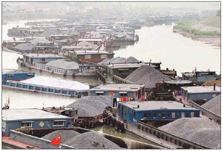
Moreover, river transport is practically turning into a specific type of technological transport, since over 70% of the cargo it transports consists of mineral building materials. It is not economically profitable to transport the latter over long distances, therefore the average distance for transporting 1 ton of cargo by river transport is constantly decreasing and currently, taking into account all types of river communications, it is less than 200 km.
Among the transported goods, the leading position is occupied by mineral construction materials (sand, gravel, crushed stone, etc.). Up to 3/4 of transported building materials are extracted by means of river transport in river beds. The next most important cargo is timber. They account for more than 1/10 of the total volume of traffic. Almost 3/4 of all timber cargo is transported in rafts, and 1/4 in the holds of ships. Therefore, the cost of transporting round timber by river transport is several times less than by rail. Whenever possible, river routes are used as much as possible for transporting timber cargo in rafts. Transportation of oil, petroleum products, coal and grain is also relatively large.
In connection with the above, the following trends can be identified for the development of river transport in Russia:
it is necessary to improve the unified system of inland waterways of Russia, which is possible through the construction of canals and locks;
it is necessary to deepen the fairway for the passage of vessels of greater carrying capacity and to extend navigation periods;
improvement of the river-sea system, which allows the use of vessels after the closure of river navigation.
Vehicles
The rolling stock is divided by purpose: freight, passenger, technical. Cargo - self-propelled and non-self-propelled, dry cargo and liquid, specialized and mixed type, as well as river-sea type vessels. Passenger – tourist and scheduled. By type of propulsion - with a wheel propulsion, with a screw propulsion, on an air cushion and hydrofoils. Technical – icebreakers, floating cranes, dredging equipment.
Figure 1. River transport rolling stock
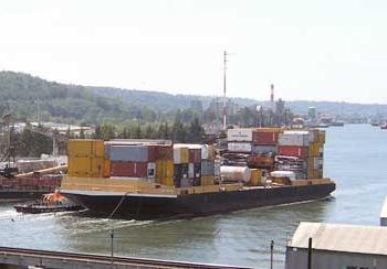
Inland waterways transport mainly goods that do not require fast delivery - construction materials (for example, sand), coal, coke, grain, etc., as well as oil and petroleum products. There are also ships that transport trucks along with their cargo and river container ships. For cargo transportation, either self-propelled vessels or tug-pushed barges are used. Barges are used primarily for bulk cargo. The largest cargo river vessels can be more than a hundred meters long and carry about five thousand tons of cargo.
However, such large vessels cannot be used everywhere. In Western Europe (primarily France, Belgium and the Netherlands), relatively small cargo ships called peniches are quite common. They are built in accordance with the minimum dimensions of locks and canals adopted in France, and therefore can be used on almost all waterways of that country. The maximum dimensions of the peniche are length 40 m, width 5.2 m, draft 2.5 m and the height of the highest part of the vessel above the waterline is 3.5 m. Peniche takes on board 300-400 tons of cargo. As a rule, the crew of a peniche consists of two people - a husband and wife, who are also the owners of the vessel. They live permanently on the ship and acquire housing on the shore only when they retire.
Large passenger river ships these days are used mainly for transporting tourists (river cruises), as well as for transporting passengers to remote areas with no road or rail connections. They have a low speed by modern standards (no more than 25 km/h) and cannot compete on equal terms with road and rail transport.
Hydrofoils and hovercraft can reach speeds of up to 80 km/h, but they have high fuel consumption and therefore high transportation costs.
Traditional (without air cushion or hydrofoils) small-sized vessels (so-called “river trams”) are used in public transport mode for urban and suburban transportation.
Special purpose vessels include floating workshops, floating stores, dredging vessels, and ferries.
Ferries are similar in function to bridges. Ferries can be self-propelled or non-self-propelled. Self-propelled ferries are driven by their own engine and propulsion and are in no way connected to the shore (unlike cable ferries). Non-self-propelled ferries include cable ferries. The energy source is a diesel engine or (on small ferries) muscle power.
River transport technology:
non-self-propelled barges using a tug;
sectional trains (6-8 barges);
group method of work on permanent freight lines according to traffic schedules;
on one ship.
Types of activities and arrangement of river ports
Reception of cargo, loading it onto ships and boarding passengers for transportation by river transport, as well as unloading cargo from ships, issuing them to recipients and disembarking passengers is carried out at coastal points. Depending on the nature and type of activity, as well as the volume of work, these points are divided into ports, piers and stopping points. River port (from the Latin word portus - fence) is a coastal point within established boundaries, connected to transport routes (railroads, automobiles) and equipped with berthing facilities, coastal structures and technical means necessary for cargo operations, storage and transshipment of goods, comprehensive fleet maintenance, and also passenger services. Marina - a coastal point that receives and issues cargo, luggage, boards and disembarks passengers, equipped with appropriate technical means to perform its functions. The pier may be connected to the railway line. Stopping point - a coastal point for boarding and disembarking passengers, as well as receiving and distributing baggage. Stopping points are usually equipped with the simplest means for berthing ships. They are assigned to nearby ports and marinas.
Ports (piers) are obliged to attract cargo and passengers to river transport, enter into contracts with shippers for transportation, accept, store and issue cargo and luggage; carry out transshipment operations and transshipment of goods from one type of transport to another; organize comprehensive fleet maintenance; process ships and other vehicles in a timely manner and send them on a voyage according to schedule and schedule: monitor the operation of the clientele’s berths and provide assistance to them if necessary; organize the movement of the fleet assigned to the port and its implementation of the transportation plan; serve passengers; make payments to clients for transportation, reloading and other work and services; create safe conditions for the movement and mooring of ships; ensure the safety of cargo, port facilities and equipment, the safety of loading and unloading and other operations, the rational use of technical means and the improvement of equipment and technology.
Based on ownership, ports are divided into ports owned by a shipping company (general purpose ports) and those owned by individual enterprises (client ports).
The production work of a port (pier) is characterized by cargo turnover and cargo processing. Under freight turnover port refers to the amount of cargo in tons that arrived at the port and at the client berths assigned to it over a certain period in ships, as well as in rafts and documented transport documents of the port (pier). The total cargo turnover of the port includes cargo turnover at arrival and departure. The port's cargo turnover is not uniform during navigation. Cargo handling – this is the amount of cargo that is reloaded at the berths of the port and clientele by the means and forces of the port.
The port consists of three main parts: the port area, the water area and the berthing front. On port area access roads, reloading equipment, warehouses, stations, workshops, garages and other structures are located. Water area – this is the water area adjacent to the coastal strip of the port. It is used for the approach and parking of ships at berths and for the construction of roadsteads where ships await cargo handling or departure on a voyage, as well as special roadsteads for performing reloading, drainage, cleaning and other work afloat. Roadsteads are equipped with devices for mooring (mooring buoys, pontoons, etc.), lighting, alarms and communications. In large ports there may be separate raids: arrivals, departures of dry cargo ships, oil tankers, etc. An integral part of the river port are raids – part of the port water area intended for the mooring of ships. Roadsteads are located away from the main shipping lane in areas that have sufficient depth and area to accommodate the required number of ships and service floating facilities. Mooring front is a section of coastline with appropriate equipment for mooring and parking of ships. To form a mooring front, mooring embankments are constructed. To protect against damage when ships hit during mooring, the berth structures are equipped with fenders in the form of wooden frames and beams, metal frames with shock absorbers, etc. Mooring bollards, eyes and bollards are used as moorings.
The port consists of separate administrative and production divisions – cargo areas, areas and berths. Berth - part of the berth front together with the adjacent water area, territory (with structures and equipment located on it), intended for the simultaneous mooring of one vessel. Cargo area is a group of geographically united berths designed for the reception and departure of certain cargo. A group of specialized berths is sometimes combined into port sections . In certain areas, berths equipped with floating reloading facilities, areas for the extraction and loading of building materials from underwater quarries, etc. can be allocated. TO auxiliary production units The port includes workshops for the repair of reloading equipment and ships, repair and construction areas, electrical networks, communications facilities, etc. For communication with main railways and roads, the port has access and intra-port roads . They are used for setting up wagons for processing. To receive, store and accumulate the necessary consignments of cargo and their release at the port, they arrange covered and open warehouses .
Classification of river fleet vessels according to the Rules of the Register of the Russian Federation
A fleet is the totality of all floating assets, united by navigation conditions (sea or river), purpose (passenger, technical), affiliation (shipping company) or other characteristics.
A vessel is a structure capable of floating on water and designed to transport goods and passengers, or create the necessary conditions for them. A modern ship is a complex engineering structure.
Vessels are classified according to a number of criteria: p about appointment; depending on the body material; depending on the availability of the power plant; according to the principle of movement, etc. This was discussed when the classification of maritime transport was considered.
According to the navigation area, the River Register of the Russian Federation divides all river fleet vessels into five classes:
“M-SP” - for mixed river-sea navigation with waves no more than 5 points, wave height up to 3.5 m, distance from ports of refuge no more than 50 miles;
“M” – for navigation on inland waterways with wave heights up to 3 m (at the mouths of large rivers, lakes, bays);
“O” – for navigation on inland waterways with wave heights of up to 2 m (in large reservoirs, in the lower reaches of large rivers);
“P” - for swimming on the middle and lower reaches of large rivers, on canals and calm lakes with wave heights of up to 1.2 m;
“L” - for navigation on rivers with wave heights of up to 0.6 m (on small rivers in the upper reaches of large rivers).
Pleasure boat class
For the purpose of identifying structural and seaworthiness qualities, pleasure boat a class formula is assigned, which in encoded form contains information about:
the type of vessel and whether it has a watertight deck;
water basins (navigation areas) where its operation is permitted;
permissible number of people on board (crew and passengers);
permissible power of the main engine in kilowatts (kW);
allowable sail area in square meters (m2).
First sign code determines the type of pleasure boat by the type of propulsion system and habitability conditions:
1 – boat;
2 – motor boat;
3 – sailing ship;
4 – sailing-motor vessel;
5 – jet ski (jet ski);
6 – rowing boat;
7 – non-self-propelled vessel;
“P” – hovercraft;
"K" - hydrofoil.
Second character of the code indicates the presence (or absence) of a recreational vessel of a watertight deck:
– ships with a watertight deck;
– open (undecked) ships.
Third character of the code indicates the number of waterproof compartments; if they are absent, a dash is placed.
Fourth character of the code , which is enclosed in parentheses, indicates the class of the pleasure craft.
Fifth character of the code indicates general permissible quantity people on board the vessel, if accommodation of people is not allowed, then a dash is placed in place of the fifth character.
Sixth character of the code through a slash with a slant to the right after the fifth character indicates the permissible power of the main engine in kW. If the design of the vessel does not provide for the main engine, then the sixth character in the formula is not written, but the line is reproduced.
Seventh character of the code through a slash with a slant to the left after the sixth character indicates the permissible sail area in square meters. If the design of the vessel does not provide for sailing, then the seventh character in the formula is not written, but the line is reproduced.
Vessel class formula for jet skis contains three characters: the first means the type of vessel (number 5), the second is written in parentheses and corresponds to the permissible wave height, and the third - the permissible number of people.
Russian River Register (RRR) is a federal government agency for ship classification, administered by the Federal Agency for Maritime and River Transport. RRR is a member of the International Association of Technical Supervision and Classification Authorities. Representatives of the Russian River Register take part in the work of the Inland Water Transport Committee of the United Nations Economic Commission for Europe, the International Maritime Organization (IMO), and the Danube Commission on harmonization and unification of requirements in the field of navigation. RRR cooperates with 19 foreign classification societies and organizations on issues of safety at sea and inland waterways.
4.4
River transport in Russia
Technical and economic features of river transport
The total length of the inland waterways of the Russian Federation is 102.7 thousand km. During navigation, the depth guarantee is maintained at approximately 40% of this length (Lena, Volga, Amur, Kama, Don, Angara, Pechera).
Advantages of river transport:
relatively low cost
high carrying capacity when using heavy-duty vessels
natural routes - minor capital investments are required when organizing shipping (6-7 times lower than for the construction of 1 km of railway or highway)
Specific energy costs for river transport are significantly lower due to low resistance to vessel movement
Disadvantages of river transport:
short-term navigation
low driving speed
the tortuosity of river routes, which lengthens the route by 3-3.5 times compared to other lines.
low speed of cargo delivery.
In the European part of the country, due to the construction of a number of connecting canals (Volga-Don, Volga-Baltic), a single deep-water system (USS) was created, connecting 5 seas: the Baltic, Caspian, White, Azov, Black. The total length of the UGS is 6.5 thousand km with a guaranteed depth of 4 meters along the entire length. Lakes and reservoirs are also used for navigation - Baikal, Ladoga, Onega, etc.
The role of inland water transport in the transport system of Russia is determined by the geography of waterways and the seasonality of their use. Because The vast majority of rivers flow in the meridian direction, and the main cargo and passenger flows of the country move in the latitudinal direction, then the importance of river transport decreases.
Navigation in Russia begins in April and continues until October (about 240 days). During other periods, icebreaking vessels are used to extend navigation. The directions and boundaries of ship passages are indicated by floating and coastal navigational signs, which are illuminated at night.
River routes are under the jurisdiction of the River Transport Department of the Ministry of Transport of the Russian Federation. These are public roads where self-rafting of timber is prohibited. Shipping routes are maintained in operational condition by special structural units: channel clearing, dredging, rock removal, etc. In sections of tracks of insufficient depth, navigation slots are created by dredging. Rock removal works ensure the expansion and deepening of ship passages. Straightening works make it possible to change the outline of river beds and increase the dimensions of the path. Trawling reveals obstacles hidden under water, which are removed during channel cleaning.
Due to the loss in 1991. In Russia, the majority of seaports and about half of the merchant fleet have significantly increased the role of river transport in providing foreign trade transportation by mixed navigation vessels. Transportation by river-sea vessels is more profitable due to the long length of the routes and the possibility of using these vessels after the closure of river navigation in winter for transportation in non-freezing sea areas.
Internal structures water transport
In inland water transport, transport routes are rivers, lakes, seas, as well as complex hydraulic structures, i.e. artificial (reservoirs, canals, locks).
Navigation does not take place along the entire width, but along the ship channel - fairway. The fairway is designed to allow passage of 2 oncoming ships. It is designated by special signs. Ship channels are arranged open, when the rivers are of the same level, and locked when the rivers are at different levels. There are also bypass channels to the gateways. The radii of the channels are at least 6 lengths of the design vessel. The channel depth is taken with a margin of one meter. Canals are fed by water, either by gravity from rivers, lakes, or by pumping water to the highest point of the canal.
Locks are built to allow ships to pass through dams, chambers with 2 end gates. Gateways are:
Single chamber gateways used when the water difference does not exceed 20-25m
Multi-chamber gateways apply when the difference is greater.
unilateral and bilateral.
Vessel classification:
by purpose: technical, auxiliary (floating docks, sanitary stations, cranes, etc.), transport, special purposes
according to the method of movement on water: self-propelled and non-self-propelled (power source outside the vessel)
according to the principle of movement: displacement, planing, hydrofoil, hovercraft, ekranoplanes (move above the surface of the water)
by the number of ridge screws – single-screw, double-screw and three-screw
by the method of performing cargo operations - with vertical loading and unloading through cargo hatches, with horizontal loading and unloading through side ports, through special cavities, pumping, etc.
The expansion of non-transshipment communication using special river-sea vessels is of great economic importance for river transport. These vessels have a carrying capacity of 2000-2700 tons.
Russia's overall need for river-sea vessels is increasing every year. Today, more than 700 such vessels belonging to various shipowners are engaged in the transportation of Russian foreign trade cargo. These ships provide transport links with foreign ports in 45 countries.
River ports and marinas
On inland waterways there are public ports, ports owned by industrial enterprises, and berths rented by clients. According to its purpose they are: passenger, cargo, cargo-passenger, military, backwaters.
Cargo ports carry out transshipment of goods from water transport to related modes of transport and back. They are divided into specialized and universal. The degree of wear of reloading equipment and equipment reaches 80%.
L – length of the mooring line; n – number of ships; t – processing time;


z – length of the vessel; a – interval between vessels.
Marina 3) pool – coastal route for boarding or disembarking passengers. The piers are floating ().
landing stages
More than half of the total volume of cargo and passenger transportation along waterways occurs in the Volga-Kama basin (construction materials). In the East of the country, the Ob-Irtysh basin (timber, oil, petroleum products, liquefied gas) occupies a leading place in terms of river transportation volumes. The southern regions of Eastern Siberia are connected with the Arctic through the Yenisei (timber cargo, coal, oil products). Timber and coal are transported along the Angara River and Lake Baikal; along the Lena - dry cargo ships, oil cargoes, timber; along the Amur and its tributaries - grain, salt, fish, timber, oil, metal, coal.
River fleet On December 20, 2000, the Board of the Ministry of Transport recorded that the state river fleet service showed that it was not ready to carry out state regulation of the activities of shipping companies. There are 32.6 thousand vessels registered in the river register. Their average age is 24 years. There are 1824 unfit vessels, and 1402 fit vessels with restrictions. The construction of new ships is progressing unsatisfactorily. For example
|
1993-1995 |
1996 |
1997 |
1998 |
1999 |
, the construction of ships at the end of the 20th century was practically not carried out: |
Plan Intrabasin |
external transportation
The main decrease in the volume of transportation and fleet renewal occurred due to a decrease in investment activity in the construction complex of the river shipping company. The largest percentage of the river fleet is occupied by tankers and oil barges. There are also ships - refrigerators, ships for transporting liquefied gas, vegetable carriers, chemical ships, car carriers (accommodating up to 500 cars).
Basics of organizing fleet movement
The river fleet has two types of traffic: free and local. Through traffic – movement on lines from loading to unloading without transshipment. Precinct
– movement along the system of traction shoulders. Through traffic is better. Depending on the purpose of the movement, the navy is divided into:
domestic (coastal) - 10%
external (foreign) – 90% Swimming is organized according to
2 forms:
linear (regular)
scheduled (irregular).< 1%. В США климат позволяет осуществлять перевозки круглый год, а в России 6 месяцев, а завоз на Крайний Север – 2-3 месяца.
In the USA the share of internal sea routes is 10%, in the Russian Federation
Currently, the figures for passenger and cargo turnover on river transport have increased slightly. TO general performance indicators of cargo water transport
River transport is an important link in the country's unified transport system. It occupies one of the leading positions in servicing large industrial centers of riverine areas.
Russia has the most widely developed network of inland waterways in the world. The length of inland waterways is 101 thousand km. The most important are tracks with guaranteed depths, which allows for the uninterrupted transportation of goods and passengers.
River transport is one of the oldest in the country; it is of particular importance for the northern and eastern regions, where the density of railways and roads is low or they do not exist at all. In these regions, the share of river transport in total freight turnover is 3.9%.
River transport has a small share in freight turnover and passenger turnover - 4th place in Russia.
This is due to the following reasons:
1). The meridional direction of river transport (while the main cargo flows are carried out in the latitudinal direction W-E; B-3, this circumstance makes it necessary to combine modes of transport, using, for example, mixed rail-water transportation).
2). The seasonal nature of river transportation (which is limited by weather conditions and sometimes time of day, for example, high-speed passenger fleets are not operated at night).
The duration of navigation on the inland waterways of Russia ranges from 145 days (in the East and North-East of the country) to 240 days (in the South and South-West).
During the inter-navigation period, ports work in cooperation with railway and road transport, despite the fact that low-speed river transport is inferior to other types of transport in terms of speed, but has its advantages.
Advantages of river transport:
1. Low cost of transportation
2. Requires less cost for the arrangement of tracks than in land modes of transport.
The importance of water transport is especially great for the Northern and Eastern regions of the country, where the railway network is insufficient, the density of the inland waterway network is 2 times greater than the average for the Russian Federation.
Hence, the share of river transport in the total freight turnover of these areas is 65-90%; in Russia as a whole, this figure is 3.7%.
The role of river transport in the country's economy is determined not so much by the scale of transport work, but by the special significance of the functions they perform.
In addition to transport services to the regions of Siberia, the Far East, including the Arctic, river transport carries out complex, expensive transportation along small rivers in hard-to-reach areas, as well as highly profitable transportation along small rivers in hard-to-reach areas, as well as highly profitable transportation of foreign trade cargo by mixed (river-sea) navigation vessels .
Currently, 5 thousand shipowners operate inland waterways various forms property.
The length of inland waterways is 101 thousand km.
Main types of river transport cargo:
Mineral building materials/sand;
Fertilizers;
Grain and other agricultural products.
According to the Ministry of Transport of the Russian Federation, the total volume of freight transportation of inland water transport during navigation in 2007 amounted to 152.4 million tons, which is 9.5% more than the level of 2006. The increase in this volume was mainly due to an increase in navigation time. Transportation of dry cargo (cement, metal, timber and construction materials) increased by 12.5%. At the same time, the volume of transportation of oil and petroleum products decreased by almost a third. More than a third of the total volume of river transportation is carried out in Privolzhsky federal district. The country's river ports handled 15% more cargo than in 2006.
State capital investments in 2007, intended for the development of inland waterway infrastructure, amounted to almost 2.6 billion rubles, which is 1.6 times more than in 2006. This made it possible to reconstruct a number of lock facilities on the Volga-Baltic Waterway ways, the Volga-Don Canal, in the Kama Basin, the Samara hydroelectric complex.
In 2008, from the state budget for the overhaul of shipping hydraulic structures river transport allocated 4 billion rubles. They are aimed at reconstructing 47 facilities.
Currently, a draft subprogram “Inland waterways” is being developed, which should become part of the Federal target program"Development of the Russian transport system in 2010-2015." The total amount of funding for this subprogram is determined in the amount of 235 billion rubles. As a result of its implementation, the share of deep-water sections in the total length of navigable rivers in the European part of our country will increase to 86%. Almost 2.5 km of new berths will be built in river ports.
- River systems and ports.
The Russian river fleet consists of 178 open joint-stock companies, including 27 shipping companies, 50 ports, 46 ship repair and shipbuilding enterprises, etc. 96 enterprises are under state control, of which 27 are state-owned enterprises, 17 are state institutions, 14 are shipping inspectorates, 14 - River Register inspections, 24 - educational institutions.
Fourteen river transport ports accept foreign ships.
The main one in Russia is the Volga-Kama river basin, to which the economically developed part of the country gravitates (40% of the river fleet's cargo turnover). Thanks to the Volga-Baltic, White Sea-Baltic and Volga-Don shipping canals, the Volga has become the core of a unified water system of the European part of Russia, and Moscow has become a river port of five seas.
The most important transport rivers in the north of the European part of Russia: Sukhona, Northern Dvina with its tributaries, Onega, Svir, Neva.
Siberia and the Far East have enormous navigable river routes. The greatest rivers of Russia flow here - the Amur, Yenisei, Lena, Ob and their tributaries. All of them are used for shipping and timber rafting, transporting food and industrial goods to remote areas. The importance of river transport for Siberia is very great, since the railway network there (especially in the meridional direction) is still insufficient.
Currently, approximately 5 thousand shipowners of various forms of ownership operate inland waterways, including about 30 joint-stock shipping companies (river shipping companies). The river fleet of the Russian Federation serves 68 republics, territories, regions and national districts.
- Technical equipment for river transport.
The material and technical base (MTB) of river transport is formed by:
Waterway (with associated structures and equipment);
Ports and marinas;
Shipyards (SSZ and SRZ);
The classification of rolling stock is shown in the figure.
The fleet (similar to sea transport) is the basis of the MTB; the main part of the technical equipment of river transport consists of vessels of various types:
Transport purposes (for transportation of goods and passengers) with a total tonnage > 14 million tons, of which< 1,5 млн. т приходится на суда смешанного плавания (река-море).
Service and auxiliary vessels (tugs, icebreakers, tankers) total capacity of tugboats is 1.6 million tons.
Technical (dredging, cranes, etc.) sharp increase in their construction costs stopped updating.
River routes are divided depending on depth and capacity into 7 classes and 4 main groups: superhighways (1st class), highways (2nd class), local routes (4th, 5th classes), small rivers (bth, 7th grades). In river transport, there are various technical structures that ensure efficient and safe operation. These are, first of all, locks for the passage of ships from one water level to another, buoys - signs to indicate dangers along the way or fencing of the fairway, gates - signs in the form of towers or pillars installed on the fairway line to indicate the direction, places of turns, etc. d.
Deep-water inland waterways have a large carrying capacity; they can be compared with multi-track railways, and they are adapted for mass transportation of goods and passengers. Transportation of some goods by river transport along main inland waterways is 2-3 times cheaper than on parallel railways.
The main differences between river vessels and sea vessels:
a) less draft;
b) overall dimensions (due to shallow depths and tortuosity of most of the river routes, as well as the narrowness of the fairway);
c) the absence of a number of elements in the design and equipment (necessary on sea-going ships, which is due to the specific conditions of navigation on rivers), while river vessels going into large lakes and sea routes are almost no different in design from sea-going vessels. Average age river vessels are 20 years old, about ½ of all transport vessels (except dry cargo barges) are more than 20 years old.
The river fleet consists of:
Self-propelled vessels (passenger, cargo, cargo-passenger);
Non-self-propelled vessels (barges for various purposes);
Tugs (pushers - vessels without their own cargo spaces, but with a power plant for traction (towing) of non-self-propelled vessels);
Specialized vessels (vegetable carriers, mobile carriers, oil ore carriers, river-sea vessels, barges, refrigerators).
A waterway is the navigable part of rivers, lakes, reservoirs and artificial canals with hydraulic structures.
The waterway is characterized by:
Depth;
Latitude;
Curvature radius (rotation);
According to the dimensions of the shipping channel, waterways are distinguished:
Superhighways – with guaranteed depths of up to 4 m;
Highways - with guaranteed depths of up to 2.6 m;
Paths of local importance - with guaranteed depths of up to 1 m.
Waterways are:
Navigable (on which safe navigation of ships is possible);
Floating (for rafting timber).
Navigable ones are distinguished: - natural (rivers and lakes);
Artificial (canals and reservoirs).
Ports are the basis of coastal river transport, where ships are loaded and unloaded, passengers board and disembark, and ship maintenance is carried out.
River ports are:
Universal (perform all types of work);
Specialized (only individual species works - cargo or passenger).
Essential Elements ports - berths - equipped with mechanized means for loading and unloading ships; there are warehouses and storage areas for bulk cargo.
A pier is an intermediate point where ships have a short stop for boarding and disembarking passengers and partial loading and unloading of cargo.
- Main performance indicators of inland water transport.
Vessel productivity is transport work in ton-kilometers or passenger-kilometers per unit of time (usually a day), calculated per 1 hp. or 1 ton lifting capacity. A distinction is made between net and gross productivity of a vessel. Net productivity characterizes the use of the vessel while underway while laden. It is determined by dividing the total amount of ton-kilometers of this type of work by the power-day (tonnage-day) of travel in a loaded state. Gross productivity is an indicator characterizing the use of the vessel during the entire operational time spent, i.e. the time of movement in loaded and unladen states, the time of all stops and non-transport work - is determined by dividing the total ton-kilometers by the force-day (tonnage-day) that the vessel is in operation.
Vessel utilization indicators by loading reflect the degree of utilization of the vessels' carrying capacity and power.
The indicator of the use of a cargo ship in terms of carrying capacity, t/t tonnage, is determined by dividing the mass of cargo loaded into the ship, Q e, for registration carrying capacity Q p:
The average load per 1 ton of cargo capacity of a cargo ship is determined by dividing ton-kilometers (where l hgr– length of travel of the vessel with cargo) per tonnage - kilometers with cargo:
![]()
Average load per 1 hp. The power of tugboats is determined by dividing the ton-kilometers performed on loaded voyages by the force-kilometers with the composition of loaded ships and rafts:
![]()
Share of running time with cargo a d is determined by dividing the tonnage-day of travel of a vessel with cargo by the total number of tonnage-days in operation:
![]()
Average productivity 1 ton of lifting capacity of self-propelled and non-self-propelled vessels M egr determined by dividing ton-kilometers by the total number of ton-days in operation:
![]()
Vessel turnaround time is the time spent moving the vessel from the point of loading to the point of unloading and back, including the time required for initial and final operations (loading, unloading, locking, etc.), delays along the way and technical operations. Determined by adding the parking time t st; time spent on maneuvers t m; running time t x:
![]()
Let's consider the performance indicators of river ports.
The total cargo turnover of the port is the total amount of cargo in tons sent from the port and received at the port. This indicator is planned and taken into account for all cargo as a whole and with distribution by nomenclature: oil and petroleum products, timber in rafts, dry cargo ships (grain, ore, coal, ore, etc.). Special emphasis is placed on cargo transported in containers, as well as those subject to transfer from river transport to railway transport and received from it.
Loading and unloading operations include all work performed by port facilities at cargo berths and warehouses related to the transshipment of goods transported by river transport. This includes port and non-port operations, as well as the transhipment of oil cargo at oil refineries. Non-port activities include the economic work of the port, as well as work performed for other organizations in order to maintain a permanent workforce and more fully utilize fixed assets.
The volume of loading and unloading operations is planned and taken into account in physical tons and ton-operations. The volume of loading and unloading operations in physical tons corresponds to the port's cargo turnover minus the total weight of various cargoes sent from the client berths and arriving at these berths, as well as timber cargo sent from the port and arriving at the port in rafts.
A ton operation is the movement of 1 ton of cargo according to a certain loading and unloading option. A variant is the completed movement of cargo, regardless of the distance, method and additional work performed (weighing, sorting, etc.). When determining the volume of transshipment work in ton operations, any work related to the movement of 1 ton of cargo in the port is taken into account, according to the following options: transport-warehouse; warehouse-transport; transport-transport; warehouse-warehouse; internal warehouse premises (performed during the main work, and on separate orders).
The ratio of the number of ton operations performed by a port to the volume of loading and unloading operations in physical tons for a certain period is called the cargo transshipment coefficient.
- Problems and prospects for the development of inland water transport.
It is necessary to improve the unified system of internal routes in Russia, which is possible with the construction of canals and locks. In the 19th century The Mariinsky system with 39 locks was built.
The system of internal routes is of defensive importance: the connection between the south of the country and the north (the route through the European water system from Odessa to St. Petersburg) is 8800 km, and along internal pathways- 4500 km.
It is necessary to deepen the fairway for the passage of vessels of greater carrying capacity to extend navigation periods; development of a system of ro-ro vessels (“Ro-Ro”) for horizontal loading, vessels of the “river-sea” type; sectional vessels (they are more economical than heavy cargo ships of the same carrying capacity with a simplified reloading system and are reconfigured depending on cargo flows); hovercraft and hydrofoils reaching speeds of up to 105 km/h; icebreakers and ships with reinforced hulls for polar conditions; increase in the carrying capacity of vessels (costs are reduced by 25-30%); increasing the comfort of passenger ships; creation of automated complexes for reloading operations; reconstruction of existing ports (Temryuk, Yeysk, Rostov, Azov, Arkhangelsk, Murmansk, etc.); the creation of dock ships for the transportation of heavy, large-sized cargo and for the delivery of cargo to places in the Arctic basin that do not have reloading equipment, and much more.
