Which countries does Russia border with? Russian state border
The total length of Russia's borders is the largest in the world and reaches 62,269 km. Of these, the length of the sea borders is 37636.6 km and the land borders are 24625.3 km. Of the maritime boundaries on the coast of the Arctic, or the Russian Arctic sector, there are 19,724.1 km, and on the sea coast - 16,997.9 km.
Maritime boundaries extend 12 nautical miles (22.7 km) from the coast, separating internal territorial waters from international ones. The border of Russia's maritime economic zone is located 200 nautical miles (about 370 km) from the coast. Within this zone, navigation of any countries is allowed, but the development and extraction of all types of natural resources located in the waters, on the bottom and in the subsoil, is carried out only by Russia. Other countries may mine here Natural resources only in agreement with the Russian government. The northern borders of the country completely pass through the waters of the seas: , East Siberian and (follow the map). Except, all of them all year round are covered with drifting multi-year pack ice, so navigation across the seas is difficult and is only possible with the use of nuclear icebreaking ships.
The eastern borders of Russia pass mainly through the waters of the Pacific Ocean and its seas: the Bering, Okhotsk and Japanese. Our country's closest maritime neighbors here are Japan and. The length of the maritime border with is 194.3 km, and with the USA - 49 km. The narrow La Perouse Strait separates Russian territorial waters from the island of Hokkaido.
In the south and southwest of Russia, maritime borders pass with countries (, and), as well as with sea waters. Across the waters and seas - with Ukraine and. connects our country with, and along it there are waterways to Europe and. Thus, Russia is one of the great maritime powers and it has both a commercial and naval fleet.
The land borders of our Motherland are very long. In the northwest our neighbors are Norway and Finland. The length of the border with is 219.1 km, and with Finland - 1325.8 km. The length of the border along the Baltic Sea coast is 126.1 km. Along the western border of Russia there are states: Estonia, Latvia, Belarus and. The land border passes through the territory of the Kaliningrad region with Lithuania. The section of the maritime border near the south-eastern part of the Baltic Sea ( sea coast Kaliningrad region) is 140 km. In addition, the length of the river border of the region with Lithuania is 206.6 km, the lake border is 30.1 km, and with Poland is 236.3 km.
The length of Russia's land border with Estonia is 466.8 km, with Latvia - 270.6 km, with Latvia - 1239 km, with Ukraine - 2245.8 km. The length of the Black Sea sea border is 389.5 km, along the Caspian Sea - 580 km, and along the Caspian Sea - 350 km.
Russia's southern border with Georgia and Azerbaijan runs along the mountain ranges of the Main Caucasus (Watershed) Range and the spurs of the Samur Range. The length of the border with Georgia is 897.9 km, with Azerbaijan - 350 km. On the coast of the Caspian Sea, the southern border of Russia with Kazakhstan runs along the Caspian lowland, along the plains and hills of the Urals and Trans-Urals, the southern outskirts of the lowland and along the river valley it approaches the foothills. The total length of the land border with Kazakhstan reaches 7598.6 km.
Russian border guards also guard land borders in the mountains and. The total length of the Tajik border reaches 1909 km.
Further east, Russia's southern border with and runs along high mountains Altai, Western and. To the east of Mongolia, Russia again borders China along the Argun and Ussuri, which are shared by both countries. The total length of land borders with China is 4209.3 km, and with China - 3485 km.
In the extreme southeast, Russia borders on the Democratic People's Republic of Korea. The length of the border is 39.4 km.
As you can see, most of the borders of our country run along natural boundaries: seas, rivers and mountains. Some of them make international contacts difficult. These are high mountain ranges covered with perennial pack ice in southern Russia. European, Barents, Baltic, Black, Azov and border rivers and river valleys contribute to Russia's diverse connections with foreign countries.
Due to the large length of longitude in Russia, the time difference is large - it is 10. Accordingly, the entire territory of the country is divided into 10 time zones. In sparsely populated areas and on the seas, time zone boundaries follow meridians. In densely populated areas, they are carried out along the borders of administrative regions, territories and autonomous republics, skirting large cities. This is done to make it easier to calculate time. Within administrative units, a single time is established. in many time zones is accompanied by a number of inconveniences and difficulties. Thus, Central Television programs from Moscow have to be repeated specifically for residents of the eastern regions of the country, since many programs there occur late at night or early in the morning. At the same time, the time difference allows you to maneuver the use of electricity. With the help of powerful transmission line systems, the maximum supply of electricity moves with the sun, making it possible to make do with fewer power plants.
Every place on Earth has its own local time. In addition, there are summer and winter local times. This is when, by order of the government of a number of states, in March-April the clock hands are moved 1 hour forward, and in September-October - 1 hour back. For the convenience of international and intercity communications, the so-called standard time is introduced. In Russia, train and plane schedules are based on Moscow time.
In the USSR, for a more rational use of the daylight hours, since 1930, clocks have been moved forward 1 hour throughout the day - this is maternity time. Maternity time of the 2nd time zone in which Moscow is located is called Moscow time.
The local time of residents of the Kaliningrad region differs by 1 hour (more precisely, by 54 minutes) from the local Moscow time, since the Kaliningrad region is located in the first time zone.
The role and importance of time in the economy and life of people is enormous. Humans and all plant and animal organisms have a “biological clock”. This is the conventional name for the ability of living organisms to move through time. Watch the animals and you will see that they have a strict daily routine. Plants also have a certain rhythm of life.
The biological clock operates under the influence of the basic daily rhythm of the Earth - its rotation around its axis, on which changes in light, air, cosmic radiation, gravity, electricity, and the length of day and night depend. Life processes inside human body are also subject to earthly rhythms. Rhythms “ biological clock” of living organisms are encoded in the cells of organisms and are inherited through natural selection, through chromosomes.
I would be grateful if you share this article on social networks:
According to the norms international law state territory is the part of the Earth's surface, including internal and territorial waters, the subsoil beneath them and the airspace over which the power (jurisdiction) of a given applies.
State border is a real line on the ground (territory, water area), defining the limits state territory.
The total length of the borders of the Russian Federation is 60 thousand 932 km, of which 22 thousand 125 km are land (including 7616 km along rivers and lakes), 38 thousand 807 km are sea (about 2/3). State boundaries are determined using two procedures - delimitation and demarcation. Delimitation is an agreement between states on the passage of the state border, demarcation— designation of the state border on the ground, securing it with border signs.
After in Russia there is the following varieties borders:
1. The old borders coincide with the borders of the former USSR (inherited from the USSR), most of which are fixed by international treaties (borders with foreign countries - Norway, Finland, Poland, China, Mongolia, North Korea).
2. New borders with neighboring countries:
- former administrative ones, formalized as state borders with CIS countries (borders with Belarus, Ukraine, Kazakhstan, Georgia, Azerbaijan);
- borders with the Baltic countries (Estonia, Latvia, Lithuania).
According to all international rules, the borders of Russia are defined over 10 thousand km. Russia accounts for more than 2/3 of all external borders CIS. Of the CIS countries, Moldova, Armenia, Turkmenistan, Tajikistan, Uzbekistan and Kyrgyzstan do not have a common border with the Russian Federation. After the collapse of the USSR, Russia lost 40% of its equipped border.
Russia is a unique country, as it has customs and other borders “extended” to the borders of the former USSR. After the collapse of the USSR, Russia and other CIS countries faced an intractable problem. On the one hand, different rates of economic reforms and inconsistency of financial and legislative systems objectively pushed them to close their economic space. On the other hand, when new state borders do not coincide with ethnic and cultural borders, public opinion does not accept the introduction of border restrictions, and most importantly, Russia was not able to quickly develop new borders in engineering and technical terms (1 km of development of the state border requires 1 billion rubles in 1996 prices). The problem of establishing customs points was acute. At the same time, integration processes in the CIS are developing weakly, contrary to global processes. Currently only valid Customs Union(Russia, Belarus, Kazakhstan, Kyrgyzstan, Uzbekistan).
The northern and eastern borders of Russia are sea (12 nautical miles), the western and southern borders are predominantly land. The large length of Russia's state borders is determined by the size of its territory and the tortuosity of the coastlines of the seas of the Arctic, Pacific and Atlantic oceans washing its shores.
The nature of the land borders in the west and east of the country is different. Borders drawn in pre-revolutionary Russia most often follow natural boundaries. When expanding the state, its borders had to be clearly fixed. In sparsely populated areas, borders had to be easily recognizable. This was ensured by the clarity of the boundaries themselves: river, mountain range, etc. This character is mainly preserved by the eastern part of the southern border.
The modern western and southwestern borders of Russia arose in a different way. These borders were previously intrastate, that is, they separated individual entities on the territory of the country. These boundaries were often changed arbitrarily, that is, to a large extent these are administrative boundaries. When such intrastate boundaries turned into interstate ones, they turned out to be almost unrelated to natural objects. This is how Russia's borders with Finland and Poland were formed. This applies even more to the borders that emerged during the collapse of the Soviet Union.
Western border of Russia
Western border Almost along its entire length it has no clearly defined natural boundaries. The border begins on the Barents Sea coast from the Varangerfjord and runs first along the hilly tundra, then along the Pasvik River valley. In this section, Russia borders with Norway (since 1944) for 200 km (Pechenga - Nikel-Petsamo region). Norway proposes to move Russia's western border in the Barents Sea to the east and, for its part, to take jurisdiction over more than 150 thousand km 2 of water area. There is no agreement with Norway on the delimitation of the continental shelf, which is one of the most promising areas of the world in terms of oil and gas reserves. Negotiations on this issue have been ongoing since 1970, the Norwegian side insists on the principle of equal distance of borders from the island possessions of the two countries. The land border is formalized with appropriate documents and demarcated (the first Russian-Norwegian border was established in 1251).
To the south, Russia borders on Finland (1300 km). The border runs along the Manselkä hill (crosses the Lotga, Nota, and Vuoksa rivers), through heavily swamped and lake-covered territory, along the slope of the low Salpouselka ridge, and 160 km southwest of Vyborg it approaches the Gulf of Finland of the Baltic Sea. From 1809 to 1917, Finland was part of the Russian Empire. An agreement on the state border was concluded with Finland, and documents on its demarcation were signed. Additionally, it will be necessary to formalize the junction of the maritime borders of Russia, Finland and Estonia. In 1962, the Soviet part of the Saimaa Canal and Maly Vysotsky Island were leased to Finland for a period of 50 years to ensure the transportation of goods from the interior of Finland with the possibility of reloading or storing them.
In the far west, on the shores of the Baltic Sea and its Gulf of Gdansk, the Kaliningrad region is located, which borders Poland (250 km) and Lithuania (300 km). Most of the border of the Kaliningrad region with Lithuania runs along the Neman (Nemunas) River and its tributary, the Sheshupa River. An agreement with Lithuania on border demarcation was signed in 1997, but there are still some disagreements between the countries regarding the drawing of the border in the lake area. Vishtinets, on the Curonian Spit and in the area of Sovetsk. There are no border problems between Russia and Poland.
From the Gulf of Finland the border follows the river. Narva, Chudskoe and Pskov lakes and then mainly along low plains, crosses the Vitebsk (Western Dvina), Smolensk-Moscow uplands (Dnieper, Sozh), the southern spurs of the Central Russian Upland (Desna, Seim, Psel, Vorskla), Donetsk Ridge (Seversky Donets, Oskol) and goes to the Taganrog Bay of the Sea of Azov. Here Russia's neighbors are Estonia, Latvia, Belarus and Ukraine.
The length of the border with Estonia is more than 400 km. According to the Non-Stat Peace Treaty, Estonia was part of Russia from 1721 to 1917, and was also part of the USSR from 1940 to 1991. Russia unilaterally demarcated its borders. Estonia laid claim to the Pechora district of the Pskov region (1500 km 2) - the former four volosts of the Petserimas district of Estonia, included in the Pskov region in 1944, part of the Kingisepp district of the Leningrad region and Ivangorod. These territories were transferred to Estonia in 1920. On May 18, 2005, the foreign ministers signed an agreement on the border between Russia and Estonia in the Gulf of Finland and Narva Gulf.
The length of the border with Latvia is 250 km. Latvia advocated the return to its jurisdiction of the Pytalovsky and Palkinsky districts of the Pskov region (1600 km 2). In Latvia, the Decree of the Presidium of the Supreme Soviet of the USSR of August 23, 1944 on the formation of the Pskov region is considered unconstitutional.
The length of the border with Belarus is about 1000 km. There are no border problems between Russia and Belarus.
The length of the border with Ukraine is about 1300 km. Work to establish the state border between Russia and Ukraine is only being carried out, while there are sufficient serious problems. In the 1930s The eastern part of Donbass, including the city of Taganrog, was transferred from Ukraine to the RSFSR. The western regions of the Bryansk region (Novozybkov, Starodub, etc.) used to belong to the Chernigov region. By decree of the Presidium of the Supreme Soviet of the RSFSR of October 29, 1948, Sevastopol was allocated as an independent administrative and economic center with a special budget and classified as a city of republican subordination. This decree, when the Crimean region was transferred from the RSFSR to the Ukrainian SSR in 1954, was not declared invalid and has not been canceled to this day. If the Crimean region was transferred insufficiently constitutionally, then the decision to transfer Sevastopol did not exist at all. The issue of the passage of the state border along the waters of the Sea of Azov and the Kerch Strait is controversial. Russia believes that the Sea of Azov with the Kerch Strait should be considered an internal sea of Russia and Ukraine, while Ukraine insists on its division. Access to the Azov and Black Seas Russian empire acquired as a result of many years of military actions against Turkey in the 16th-18th centuries. In 1925, at the base of the 11-kilometer Tuzla Spit in the far west of the Taman Peninsula, a shallow channel was dug for the passage of fishing boats. In January 1941, the Presidium of the Supreme Soviet of the RSFSR changed the border (then administrative) in this place, now transferring the “island” of Tuzla from the Temryuk region of the Krasnodar Territory to the Crimean Autonomous Soviet Socialist Republic. In 1971, this “agreed administrative border between the Krasnodar Territory and Crimea” was once again confirmed. As a result, after the declaration of independence of Russia and Ukraine, the only navigable Kerch-Yenikalinsky fairway completely ended up on the territory of Ukraine, as well as approximately 70% of the Azov Sea. Ukraine charges a fee for the passage of Russian ships through the Kerch Strait.
Southern border of Russia
Southern border predominantly land, starts from the Kerch Strait, connecting the Azov and Black Seas, passes through the territorial waters of the Black Sea to the Psou River. The land border with Georgia and Azerbaijan begins here. The border runs along the Psou valley, and then mainly along the Main, or Watershed Range of the Greater Caucasus (Mounts Elbrus, Kazbek), passes to the Side Range in the area between the Roki and Kodori passes, then again goes along the Watershed Range to Mount Bazarduzu. Then the border turns north to the Samur River, along the valley of which it reaches the Caspian Sea. Thus, in the Greater Caucasus region, the Russian border is clearly defined by natural boundaries. This is due to the fact that nature limited the possibilities of settlement of the peoples of the Caucasus by its steep, high mountain slopes. The length of the Russian border in the Caucasus is more than 1000 km.
In the North Caucasus, Russia borders Georgia and Azerbaijan. There is a whole bunch of border problems here. The establishment of the state border is primarily related to the resolution of conflicts between Georgia and the “unrecognized entities” - Abkhazia and South Ossetia. During the Great Patriotic War, in connection with the deportation of some peoples of the North Caucasus (Karachais, Balkars, Chechens), their national-territorial entities were liquidated, and the territories were “distributed” among their neighbors, including Georgia. The restoration of previously liquidated entities and changes in borders took place in 1957.
Further, the Russian border passes through the Caspian Sea. Currently, Russian-Iranian agreements on the division of the Caspian Sea are in force. But the new sovereign Caspian states - Azerbaijan, Turkmenistan and Kazakhstan - demand the division of the Caspian Sea and its shelf, which is exceptionally rich in oil. Azerbaijan, without waiting for the final determination of the status of the Caspian Sea, has already begun to develop its subsoil.
From the coast of the Caspian Sea near the eastern edge of the Volga delta, the longest land border between Russia and Kazakhstan begins. The border runs along the deserts and dry steppes of the Caspian lowland (lake Baskunchak, Elton, the Maly and Bolshoi Uzei rivers, General Syrt, the Ural and Ilek rivers), passes at the junction of Mugodzhar and the Urals, then along the Trans-Ural plateau and the southern steppe part of Western Siberia ( Barabinskaya lowland, Kulundinskaya plain) and along the Altai mountains.
The border between Russia and Kazakhstan is the longest (over 7,500 km), but is almost not fixed by natural boundaries. For example, along the territory of the Kulundiiskaya Plain at a distance of about 450 km, the border runs from northwest to southeast almost in a straight line, parallel to the direction of the Irtysh flow. Still, about 1,500 km of the border runs along the Maly Uzen (Caspian) and Ural rivers, its left tributary - the Ilek River, along the Tobol and its left tributary - the Uy River (the longest river border with Kazakhstan), as well as along a number of smaller ones tributaries of the Tobol. The eastern part of the border with Kazakhstan, passing through Altai (Mount Belukha), is clearly defined. The border runs along the ridges separating the Katun basin from the Bukhtarma basin - the right tributary of the Irtysh (Koksuysky, Kholzunsky, Listvyaga, in small areas - the Katunsky ridge and Southern Altai).
There is a very conventional old “inter-republican” border between Russia and Kazakhstan. The borders of Northern Kazakhstan were proclaimed back in 1922 - various public organizations raised the issue of changing the border between Russia and Kazakhstan, which had not yet been formalized. It was proposed to transfer to Kazakhstan parts of the Russian regions bordering the republic (Astrakhan, Volgograd, Orenburg, Omsk, Kurgan and Altai Territories), on the other hand, we are talking about transferring the northern regions of Kazakhstan (North Kazakhstan, Kokchetav, Tselinograd, Kustanai) to Russia. , East Kazakhstan, Irtysh part of Pavlodar and Semipalatinsk, northern parts of the Ural and Aktobe regions). According to the 1989 population census, about 470 thousand Kazakhs lived in the south of Russia, and in the northwest, north and northeast Kazakhstan - more than 4.2 million Russians. Currently, Russia and Kazakhstan have signed an agreement on the delimitation of the state border.
Almost the entire border of Russia from Altai to the Pacific Ocean runs along the mountain belt. At the junction of the ridge in Southern Altai, Mongolian Altai and Sailyugem there is the Tabyn-Bogdo-Ula mountain junction (4082 m). The borders of three states meet here: Russia, China and Mongolia.
The border with Mongolia runs along the Sailyugem ridge (Western Tannu-Ola, Eastern Tannu-Ola, Sengilen, Eastern Sayan - Mount Munku-Sardyk, 3492 m), the northern edge of the Ubsunur depression, the mountain ranges of Tuva, the Eastern Sayan (Big Sayan) and the ridges Transbaikalia (Dzhidine Kiy, Ermana and a number of others). The length of the borders is about 3000 km. A border agreement and demarcation agreements have been signed between Russia and Mongolia.
The border with China follows the river. Argun (Nerchinsky ridge), Amur (Borschovochny ridge, Amur-Zeyskaya plain, the city of Blagoveshchensk, the Zeya river, the Zeya-Bureya lowland, the Bureya river, the city of Khabarovsk, the Lower Amur lowland), Ussuri and its left tributary - the Sungacha river. More than 80% of the Russian-Chinese border runs along rivers. The state border crosses the northern part of the water area of Lake Khanka (Prikhankai Lowland) and runs along the Pogranichny and Black Mountains ridges. Russia borders China for 4,300 km. The western section of the Russian-Chinese border is delimited, but not demarcated. Only in 1997 was the demarcation of the Russian-Chinese border on the eastern section completed, several border islands on the river. The Argun and Amur with a total area of 400 km2 were left for “joint economic use”; in 2005, almost all the islands within the rivers’ water areas were demarcated. China's claims to Russian territory (then the territory of the USSR) were declared to their maximum extent in the early 1960s. and covered the whole Far East and Siberia.
In the extreme south, Russia borders North Korea along the river. Foggy (Tumynjiang). The length of the border is only 17 km. Along the river valley, the Russian-Korean border reaches the coast of the Sea of Japan south of Posyet Bay. Russia and the DPRK signed an agreement on border demarcation and maritime delimitation.
Eastern border of Russia
Eastern border Russian maritime. The border runs along the Pacific Ocean and its seas - the Japanese. Okhotsky, Beringov. The border with Japan runs along the La Perouse, Kunashirsky, Izmena and Sovetsky straits, which separate the Russian islands of Sakhalin, Kunashir and Tanfilyev (Lesser Kuril Ridge) from the Japanese island of Hokkaido.
Japan disputes with Russia the islands of the Lesser Kuril ridge (Iturup, Kunashir, Shikotan and the Habomai ridge with a total area of 8548.96 km 2), called the “northern territories”. The dispute is about the state territory and waters of the Russian Federation with a total area of 300 thousand km 2, including the economic zone of islands and the sea, rich in fish and seafood, and a shelf zone with oil reserves. In 1855, an agreement was concluded with Japan, according to which the islands of the Lesser Kuril Ridge were transferred to Japan. In 1875, all the Kuril Islands passed to Japan. As a result of the Russo-Japanese War, under the Treaty of Portsmouth in 1905, Russia ceded Southern Sakhalin to Japan. In September 1945, after Japan signed the act of unconditional surrender, the Kuril Islands and Sakhalin Island became part of the USSR, but the San Francisco Treaty of 1951, which seized the Kuril Islands from Japan, did not determine their new nationality. According to the Japanese side, the South Kuril Islands have always belonged to Japan and are in no way connected with the 1875 treaty; they are not part of the Kuril chain, but of the Japanese Islands, and therefore are not subject to the San Francisco Treaty.
The border with the United States is located in the Bering Strait, where the Diomede Island group is located, and runs along a narrow (5 km wide) strait between the Russian Ratmanov Island and the American Kruzenshtern Island. Border problems with the US have been resolved. In 1867, the Russian Empire, during the reign of Alexander II, sold Alaska for $7 million. There are certain difficulties in the final establishment of the maritime border between Russia and the United States in the Bering Strait (“Shevardnadze zone”). The Russia-US border is the longest maritime border in the world.
Northern border of Russia
Northern border Russia, like the eastern one, is maritime and passes through the seas of the Arctic Ocean. The Russian sector of the Arctic is limited by conditional lines running in the west from the Rybachy Peninsula and in the east from Ratmanov Island to the North Pole. The meaning of the concept of “polar possessions” is revealed in the Resolution of the Central Executive Committee (CEC) and the Council of People's Commissars (SNK) of the USSR dated April 15, 1926, adopted on the basis of the International Concept on the division of the Arctic into sectors. The Resolution proclaimed “the right of the USSR to all islands and lands in the Arctic sector of the USSR.” There is no talk of any affiliation of the water areas of this sector with Russia. Along the northern coast and islands of the Arctic, Russia owns only its territorial waters.
Russia is the largest state in the world. It’s clear that when I look at the territory of my homeland on a map, I’m tempted to look at who the neighbors are, what countries surround us. And, sometimes, this question is not an idle one, but much more pressing. Well, we simply have to know, I think, what kind of people, what kind of neighbors live outside the country.
What countries neighbor Russia?
The most big number states neighbors our homeland on the southeastern and southern sides. Of these, the largest can be named:
- China;
- Korea;
- Mongolia;
- Kazakhstan;
- Japan.

Of course, we are greatly influenced by the people of these amazing countries. They influence both positively and negatively. It is undoubtedly very good that such extensive cultural and religious exchange is possible. But remember about the penetration of weapons and drugs into us!
Closest neighbors
Of course, one cannot help but remember former republics THE USSR. Armenia, Kazakhstan and Georgia, Ukraine and Belarus, Baltic republics. People in Russia feel a pull and a special attachment to the residents of these countries.

Also, it should be noted that countries such as Ukraine and Belarus have a lot in common with the residents of Central Russia. These are people of the same Caucasian race, with languages very similar to ours. We have the same, for example, religion, cultural characteristics and historical origins.
In the west are European powers
Our neighbors to the west are European countries. This is a large and historically very highly developed territory. Europe is an important part of our continent and includes a huge number of countries. Of course, these states are much smaller than Russia, but each has its own flavor and attractiveness for tourists.

And the countries closest to our border now are those located on the Baltic Sea coast. That is why this region is called the Baltic States. Which states does Russia border on the west? These are Lithuania, Latvia and Estonia. All the capitals of the Baltic republics are very beautiful cities, with their own zest. There is something to see in Vilnius and Riga, as well as in Tallinn. Very nice reviews!
Russian Federation- the largest state on the planet. Its area is estimated at millions of square kilometers. Which countries border Russia? And what are the peculiarities of the geopolitical situation of this country? This will be discussed in this article.
Which countries border Russia?
Russia is the leading country on the planet in terms of size. Its area is just over 17 million square kilometers. True, only 146 million people live on such a vast territory, so the average population density in the country is low (8.4 people per square kilometer of area). How many countries does Russia border with?
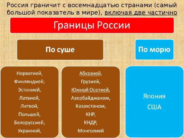
If we take into account all countries, including those partially recognized by the world community (we are talking about Abkhazia and South Ossetia), then Russia is the world leader in the number of neighboring countries. There are 16 of them in total.
Which countries border Russia? These are Norway, Finland, Latvia, Lithuania, Estonia, Poland, Ukraine, Georgia, Azerbaijan, Belarus, Kazakhstan, China, Mongolia, North Korea, as well as South Ossetia and Abkhazia. Russia borders on two more countries by sea: Japan and the USA.
Features of the geopolitical situation of modern Russia
Geopolitical models view Russia as a major player surrounded by so-called large spheres (according to Cohen). In the west there is a bloc of NATO countries, which is moving closer and closer to the state borders of the Russian Federation. By the beginning of the 21st century, this bloc had completely extended its influence to the Balkan Peninsula, the Baltic states and Eastern Europe. In the south, Russia borders on another powerful player - China, which has significant military and economic potential.
If we consider the purely economic aspect of the geopolitical situation, then Russia is surrounded on all sides by members of the so-called economic Triad of the planet. These are the European Union in the west (about 20% of global GDP), Japan in the east (9%) and China in the south (18%).

Let us consider in more detail the western, southern and eastern sectors of the Russian state border.
Western borders of Russia
The western border of Russia begins on the shores of the Barents Sea and practically does not encounter natural boundaries along its route. Which countries does Russia border on the west? These are six independent states that were previously part of the USSR, as well as two Scandinavian countries (Norway and Finland).
In the west, the longest section of the border is between the Russian Federation and Ukraine (about 1,300 km), and the shortest is with Norway (200 km). It should be noted that there are no border problems or any territorial claims only between Russia and Belarus in this area. The Crimean Peninsula is the main object of dispute with Ukraine, the Pskov region - with Latvia. Norway also lays claim to part of the Barents Sea that belongs to Russia.

Southern borders of Russia
What countries does Russia border on in the south? These are Georgia, Azerbaijan, Kazakhstan, China, Mongolia, as well as two unrecognized republics - South Ossetia and Abkhazia.
The longest section of the Russian border is with Kazakhstan (almost 7,500 kilometers). This line is very arbitrary and practically does not coincide with natural objects (it runs through desert areas or mountain ranges).
Perhaps the most problematic area for Russia is the section of the border in the North Caucasus. There is a whole set of hot spots associated with the unrecognized formations of Abkhazia and South Ossetia.
Eastern borders of Russia
In the east, Russia borders the DPRK by land, as well as Japan and the United States by sea.
The Russian-Korean border is the shortest - only 18 kilometers. It runs entirely along the Tumannaya River. The countries agreed among themselves on the demarcation and delimitation of water areas in the Sea of Japan.

Russia borders two other states in the east solely by sea. The Russian-American maritime border is considered the longest in the world. It should be recalled that Alaska was once sold by Alexander II to the States for seven million dollars.
Serious territorial claims also remain between Russia and Japan. The object of the dispute is a number of islands of the Kuril chain.
Finally...
Now you know which countries border Russia. These are 16 independent states, as well as two partially recognized republics. Unfortunately, problems with the demarcation of many sections of the Russian state border have not yet been resolved. In addition, many neighboring countries make territorial claims against the Russian Federation.
The Russian Federation is a huge country, ranking first in the world in terms of area. The states bordering Russia are located from all directions of the world, and the border itself reaches almost 61 thousand km.
Types of borders
The border of a state is the line that limits its actual area. Territory includes areas of land, water, underground minerals and airspace located within a country.
There are 3 types of borders in the Russian Federation: sea, land and lake (river). The sea border is the longest of all, it reaches about 39 thousand km. The land border is 14.5 thousand km long, and the lake (river) border is 7.7 thousand km long.
General information about all states bordering the Russian Federation
Which states does the Federation recognize its neighborhood with? 18 countries.
Name of states bordering Russia: South Ossetia, Republic of Belarus, Republic of Abkhazia, Ukraine, Poland, Finland, Estonia, Norway, Latvia, Lithuania, Kazakhstan, Georgia, Azerbaijan, United States of America, Japan, Mongolia, China First order countries are listed here .
Capitals of states bordering Russia: Tskhinvali, Minsk, Sukhum, Kiev, Warsaw, Oslo, Helsinki, Tallinn, Vilnius, Riga, Astana, Tbilisi, Baku, Washington, Tokyo, Ulaanbaatar, Beijing, Pyongyang.
South Ossetia and the Republic of Abkhazia are partially recognized because not all countries in the world have recognized these countries as independent. Russia did this in relation to these states, therefore, it approved the neighborhood and borders with them.
Some states bordering Russia argue about the correctness of these borders. For the most part, disagreements arose after the end of the USSR.

Land borders of the Russian Federation
The states bordering Russia by land are located on the Eurasian continent. These also include lake (river) ones. Not all of them are currently protected; some of them can be easily crossed with only a passport of a citizen of the Russian Federation, which is not always available mandatory is being checked.
States bordering Russia on the mainland: Norway, Finland, Belarus, South Ossetia, Ukraine, Republic of Abkhazia, Poland, Lithuania, Estonia, Kazakhstan, Latvia, Georgia, Azeybardzhan, Mongolia, People's Republic of China, North Korea.
Some of them also have a water border.
Available Russian territories, which are surrounded on all sides by foreign countries. Such areas include the Kaliningrad region, Medvezhye-Sankovo and Dubki.
You can travel to the Republic of Belarus without a passport and any border control along any of the possible roads.
Maritime borders of the Russian Federation
Which states does Russia border by sea? The sea border is considered to be a line 22 km or 12 nautical miles from the coast. The country's territory includes not only 22 km of water, but also all the islands in this sea area.
States bordering Russia by sea: Japan, the United States of America, Norway, Estonia, Finland, Poland, Lithuania, Abkhazia, Azerbaijan, Kazakhstan, Ukraine, North Korea. There are only 12 of them. The length of the borders is more than 38 thousand km. Russia has only a maritime border with the USA and Japan; there is no land boundary line with these countries. There are borders with other states both by water and by land.

Settled disputed sections of the border
At all times, there have been disputes between countries over territories. Some of the disputing countries have already agreed and are no longer raising this issue. These include: Latvia, Estonia, People's Republic of China and Azerbaijan.
The dispute between the Russian Federation and Azerbaijan occurred over a hydroelectric complex and water intake structures that belonged to Azerbaijan, but were in fact located in Russia. In 2010, the dispute was resolved, and the border was moved to the middle of this waterworks. Now water resources The countries use this hydroelectric system in equal shares.
After the collapse of the USSR, Estonia considered it unfair that the right bank of the Narva River, Ivangorod and the Pechora region remained the property of Russia (Pskov region). In 2014, the countries signed an agreement on the absence of territorial claims. The border did not suffer any noticeable changes.

Latvia, like Estonia, began to lay claim to one of the districts of the Pskov region - Pytalovsky. An agreement with this state was signed in 2007. The territory remained the property of the Russian Federation, the border did not change.
The dispute between China and Russia ended with the demarcation of the border along the center of the Amur River, which led to the annexation of part of the disputed territories to the People's Republic of China. The Russian Federation transferred 337 square kilometers to its southern neighbor, including two plots in the Tarabarov region and one plot near Bolshoi Island. The signing of the agreement took place in 2005.
Unsettled disputed sections of the border
Some disputes over territory are not closed to this day. It is not yet known when the agreements will be signed. Russia has such disputes with Japan and Ukraine.
The Crimean Peninsula is a disputed territory between Ukraine and the Russian Federation. Ukraine considers the 2014 referendum illegal and Crimea occupied. The Russian Federation established its border unilaterally, while Ukraine passed a law creating a free economic zone on the peninsula.
The dispute between Russia and Japan is over the four Kuril Islands. The countries cannot come to a compromise because both believe that these islands should belong to them. These islands include Iturup, Kunashir, Shikotan and Habomai.
Boundaries of exclusive economic zones of the Russian Federation
An exclusive economic zone is a strip of water adjacent to the border of the territorial sea. It cannot be wider than 370 km. In this zone, the country has the right to develop subsoil resources, as well as to explore and preserve them, to create artificial structures and their use, and to study water and the bottom.
Other countries have the right to move freely through this territory, install pipelines and otherwise use this water, but they must take into account the laws of the riparian state. Russia has such zones in the Black, Chukchi, Azov, Okhotsk, Japanese, Baltic, Bering and Barents seas.